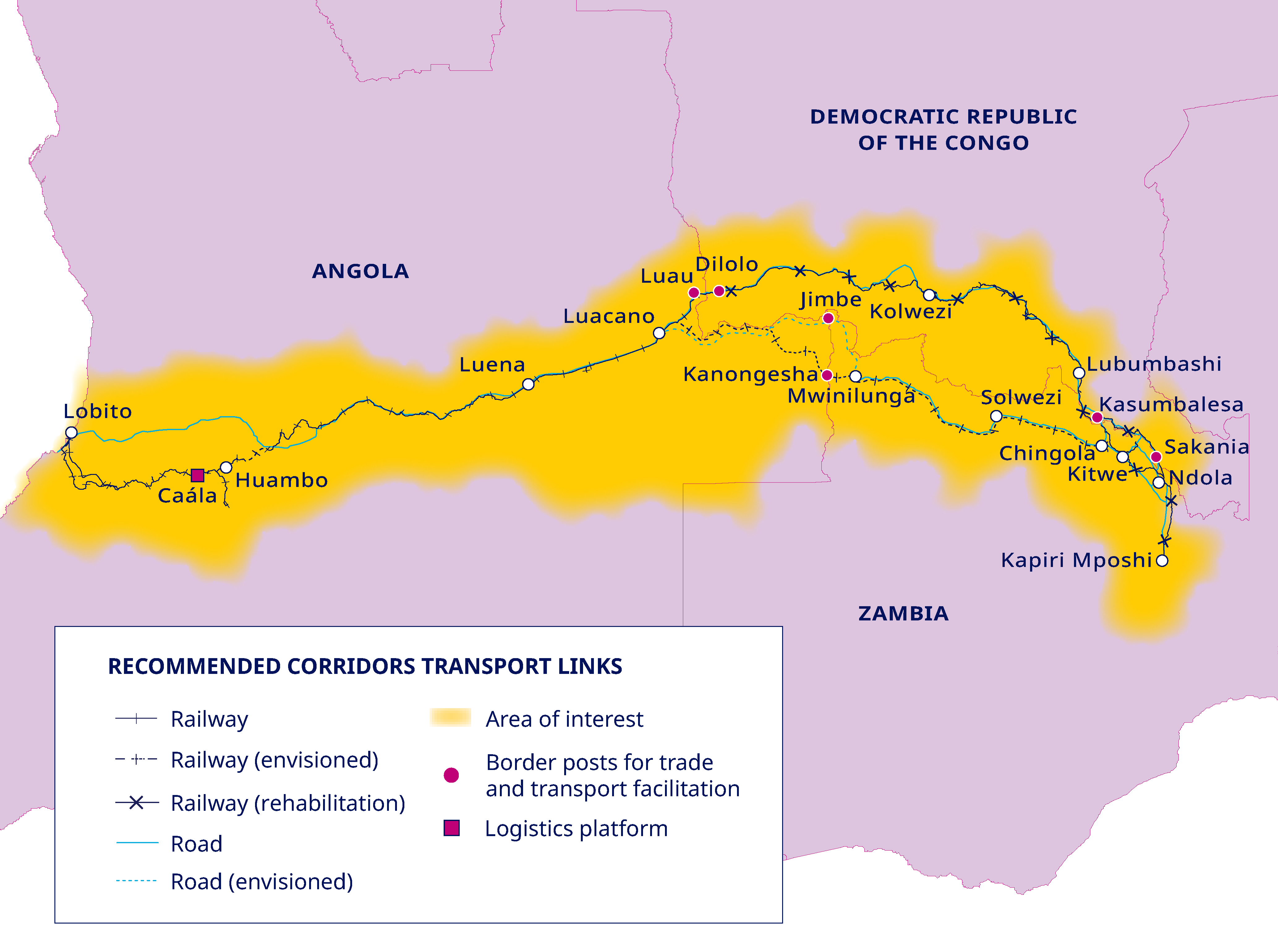
- Route Overview
- Angola — Atlantic Section (Lobito to Huambo)
- Angola — Highland Section (Huambo to Luau)
- DRC — Western Section (Dilolo to Kolwezi)
- DRC — Copperbelt Section (Kolwezi to Lubumbashi)
- Zambia Connection and Planned Direct Extension
- Branch Lines & Connections
- Key Junctions & Interchanges
- Geographic Challenges
Route Overview
Route Intelligence View
This page treats the route map as an operating system: port capacity, rail reliability, border processing, mine loading, and competing corridors all determine whether the Atlantic route becomes commercially dominant.
The Lobito Corridor is best understood as a family of connected and planned route segments from the Port of Lobito on Angola's Atlantic coast to the mining heartlands of the Democratic Republic of the Congo and Zambia. The operating Angolan spine is approximately 1,300 kilometres from Lobito to Luau, while Lobito Atlantic Railway describes the Kolwezi-to-Lobito route as 1,739 kilometres including the DRC access section. The planned direct Zambia-Lobito rail link is a separate greenfield project intended to connect Chingola in Zambia to Luacano in Angola. The corridor traverses three sovereign nations, four distinct climatic zones, and terrain ranging from sea-level coastal plains to highland plateaux exceeding 1,700 metres in elevation.
The route is best understood as several principal segments, each with distinct geography, operational characteristics, and infrastructure conditions. From west to east, these are: the Angolan Lobito-Luau spine, officially 1,289 kilometres in MIGA project documents and commonly rounded by LAR to 1,300 kilometres; the DRC access section from Luau/Dilolo to Kolwezi, which LAR describes as 450 kilometres under its SNCC track-access arrangement; the wider SNCC Copperbelt rail network from Kolwezi toward Lubumbashi and Sakania; the existing DRC-Zambia rail connection through Kasumbalesa; and the planned direct Zambia-Lobito greenfield link from Chingola to Luacano.
The entire corridor uses Cape gauge (1,067 mm), the standard for southern and central African rail networks. This shared gauge enables through-running of rolling stock across the Angolan, Congolese, and Zambian rail systems, although differences in track condition, signalling standards, and axle-load limits between the three national networks create practical constraints on interoperability. The Angolan segment, operated by the Lobito Atlantic Railway (LAR) consortium under a 30-year concession, represents the most modern and best-maintained portion of the route. The DRC segment, under the Société Nationale des Chemins de fer du Congo (SNCC), requires the most extensive rehabilitation. The Zambian segment connects to the relatively well-maintained network operated by Zambia Railways Limited.
Route Intelligence Summary
For corridor analysis, the map is not just geography. It is a bottleneck map. The route's commercial performance turns on four handoffs: rail-to-port at Lobito, LAR-to-SNCC at Luau/Dilolo, DRC mine loading around Kolwezi and Lubumbashi, and the Zambia connection south of the DRC border.
- Most bankable segment: Angola's Lobito-Luau line, because it has the concession structure, operator, and rehabilitation program already in place.
- Highest operational risk: Dilolo-Kolwezi, where track condition, bridge integrity, and SNCC capacity can cap the whole corridor.
- Most strategic optionality: the Zambia extension, which would add the Solwezi and Northwestern Province mining cluster to the Atlantic route.
- Most important non-track asset: border processing, because days lost at Luau/Dilolo or Kasumbalesa can erase rail transit-time gains.
End-to-End Summary
| Segment | From | To | Distance (approx.) | Operator | Status |
|---|---|---|---|---|---|
| Angola — Lobito-Luau spine | Lobito | Luau | 1,289 km official; ~1,300 km rounded | LAR / CFB | Operational, ongoing rehabilitation |
| DRC — Access section | Dilolo / Luau | Kolwezi | 450 km in LAR public materials | SNCC, with LAR track access | Partially operational, heavy rehabilitation needed |
| DRC — Copperbelt network | Kolwezi | Lubumbashi / Sakania | Separate SNCC network section | SNCC | Operational but rehabilitation and concession structure unresolved |
| Zambia — Copperbelt | Kasumbalesa | Ndola | ~280 km | Zambia Railways | Operational |
| Zambia-Lobito direct link | Chingola | Luacano | 830 km (AFC); 485 miles / ~780 km ESIA scope (USTDA) | AFC lead developer | Pre-construction / ESIA |
Angola — Atlantic Section (Lobito to Huambo)
The corridor begins at the Port of Lobito, situated on one of the finest natural deep-water harbours on Africa's Atlantic seaboard. The port sits on a narrow sand spit at the southern end of a bay in Benguela Province, at an elevation of essentially zero metres above sea level. Rail sidings and container yards connect directly to the quayside, allowing mineral concentrates, containers, and bulk cargo to transfer between ship and train without intermediate road haulage. The port is currently undergoing a major expansion programme to increase capacity for bulk mineral exports, containerized freight, and petroleum products.
From the port, the Benguela Railway runs southeast through the coastal lowlands for approximately 35 kilometres to the provincial capital of Benguela (population approximately 560,000), Angola's third-largest city and a significant commercial centre. This initial segment crosses flat to gently undulating terrain, passing through the semi-arid coastal strip that characterizes the Angolan littoral. Elevation gain over this stretch is negligible.
East of Benguela, the line begins its dramatic ascent from the coastal plain into the interior highlands. Over approximately 120 kilometres, the railway climbs from near sea level to roughly 600 metres, following river valleys and traversing a series of engineered curves that wind through increasingly rugged terrain. The gradient on this section averages roughly 1.5 percent but reaches as steep as 2.5 percent in several stretches, requiring the original engineers to employ reverse curves and switchbacks to maintain workable gradients for loaded mineral trains. This is the most topographically challenging portion of the entire Angolan segment and contains several of the line's major bridges, spanning river gorges that cut through the escarpment separating the coastal lowlands from the plateau.
The escarpment section passes through the town of Cubal (formerly Robert Williams, named after the railway's founder), an important intermediate station at approximately 400 metres elevation. Cubal serves as a crew change point and fueling stop, and the surrounding agricultural region generates maize, beans, and cassava freight that contributes to the line's commercial viability beyond mineral traffic. Continuing east and upward, the railway passes through Ganda and Caimbambo before reaching the western approaches to Huambo.
Huambo (formerly Nova Lisboa under Portuguese rule) is the corridor's most significant intermediate city, with a population exceeding 700,000. It sits on the central Angolan plateau at approximately 1,700 metres above sea level, making it one of the highest major cities in southern Africa. The Huambo railway station is the largest on the Benguela Railway, serving as the primary maintenance depot, locomotive workshop, and operational headquarters for the LAR concession. The 350-kilometre journey from Lobito to Huambo encompasses the full elevation gain from sea level to the plateau and represents the most infrastructure-intensive portion of the Angolan segment, with the highest concentration of bridges, culverts, and engineered gradients.
Key Stops: Lobito to Huambo
| Station | Km from Lobito | Elevation (approx.) | Notes |
|---|---|---|---|
| Lobito (Port) | 0 | ~5 m | Corridor origin; deep-water port; mineral terminal |
| Catumbela | 12 | ~10 m | Industrial zone; Catumbela River bridge |
| Benguela | 35 | ~30 m | Provincial capital; major freight yard |
| Cubal (Robert Williams) | 130 | ~400 m | Crew change point; escarpment town |
| Ganda | 185 | ~900 m | Agricultural centre |
| Caimbambo | 220 | ~1,100 m | Intermediate halt; steep gradients west of station |
| Huambo (Nova Lisboa) | 350 | ~1,700 m | Main depot; LAR operational HQ; workshops |
Angola — Highland Section (Huambo to Luau)
East of Huambo, the Benguela Railway enters the vast Angolan central plateau, a region of gently rolling savanna grassland at altitudes between 1,400 and 1,800 metres. The terrain here is far less demanding than the escarpment section to the west, and the railway runs through long, sweeping curves across an open landscape of miombo woodland, seasonal wetlands, and subsistence farming communities. The gradients on this stretch rarely exceed 1 percent, and much of the line runs on near-level terrain, making it the fastest and most efficient section for heavy freight operations.
The first major station east of Huambo is Kuito (formerly Silva Porto), the capital of Bié Province, located approximately 160 kilometres east of Huambo at an elevation of roughly 1,700 metres. Kuito was one of the cities most devastated by Angola's civil war, and the railway infrastructure here required complete reconstruction during the Chinese-funded rehabilitation between 2005 and 2014. The station has been rebuilt and serves as an important agricultural loading point for maize and livestock, as well as a passenger stop serving a population of approximately 185,000.
Beyond Kuito, the line continues east through a succession of smaller towns and halts: Camacupa, Coemba, and Munhango. This stretch passes through some of Angola's least densely populated territory, crossing the headwaters of several major river systems including tributaries of the Cubango (Okavango) and Zambezi rivers. The sparse population and limited economic activity along this stretch mean that the railway's primary function here is as a transit corridor rather than a generator of local freight, though LAR has been developing agricultural initiatives to stimulate demand.
Luena (formerly Luso), the capital of Moxico Province, is located approximately 800 kilometres east of Lobito at an elevation of roughly 1,330 metres. Luena marks the beginning of the eastern descent from the plateau toward the DRC border. It is the last major Angolan city on the line and serves as a significant logistics node, with warehousing, customs clearance facilities, and a growing commercial zone stimulated by the railway's revival. The Moxico region surrounding Luena is also the site of significant untapped mineral potential, including diamond deposits and rare earth prospects.
The final 540 kilometres from Luena to Luau cross increasingly flat terrain as the plateau gradually descends toward the Congo basin watershed. The line passes through Lumeje and Luacano junction (where the Luacano-Jimbe branch diverges northward) before reaching the border. The track condition on this far-eastern stretch of the Angolan segment has historically been the weakest, as these areas were the last to be rehabilitated and are the most remote from the maintenance depots at Huambo and Benguela. LAR's ongoing investment programme has prioritized improvements to sleepers, ballast, and drainage on this section to bring it up to the standard of the western portions.
Luau itself is a small border town at approximately 1,100 metres elevation, situated on the Luau River which forms the international boundary between Angola and the DRC. The station includes customs and immigration facilities, rail interchange sidings, and a gauge-compatible cross-border connection to the DRC's rail network. The border crossing at Luau/Dilolo is the single most critical node in the entire corridor, as all east-west rail traffic must pass through this bottleneck. Modernization of border processing facilities, including digital customs documentation and coordinated inspection protocols, is a priority under the Lobito Corridor Trilateral Free Trade Agreement (LCTTFA).
Key Stops: Huambo to Luau
| Station | Km from Lobito | Elevation (approx.) | Notes |
|---|---|---|---|
| Huambo | 350 | ~1,700 m | Plateau junction; main depot |
| Londuimbali | 400 | ~1,750 m | Highest point on the line |
| Kuito (Silva Porto) | 510 | ~1,700 m | Bié Province capital; agricultural hub |
| Camacupa | 590 | ~1,600 m | Intermediate halt; river crossing |
| Coemba | 665 | ~1,500 m | Small station; sparse population zone |
| Munhango | 720 | ~1,400 m | Zambezi headwaters region |
| Luena (Luso) | 800 | ~1,330 m | Moxico capital; customs/logistics hub |
| Lumeje | 940 | ~1,200 m | Eastern halt; diamond region |
| Luacano Junction | 1,050 | ~1,150 m | Branch point for Luacano-Jimbe spur |
| Luau | 1,289 official project line / historical route-post references vary | ~1,100 m | Angola-DRC border; customs interchange |
DRC — Western Section (Dilolo to Kolwezi)
The corridor enters the Democratic Republic of the Congo at Dilolo, the Congolese counterpart to Luau on the opposite bank of the border river. Dilolo sits in the Lualaba Province at approximately 1,060 metres elevation. The town has historically functioned as a border trading post and customs clearance point, and its railway station is the western terminus of the DRC's Chemin de fer du Katanga network, operated by the SNCC. The border interchange at Dilolo requires coordination between the Angolan LAR system and the Congolese SNCC, including documentation handoffs, locomotive changes (in some cases), and customs inspections. Reducing the time required for these border procedures from the current average of 48 to 72 hours to a target of under 12 hours is a central objective of the corridor's operational improvement programme.
From Dilolo, the DRC access route runs east-southeast to Kolwezi. LAR describes the Luau-to-Kolwezi section as 450 kilometres; older station-distance tables and secondary sources can show shorter Dilolo-Kolwezi figures depending on whether they count only specific sub-sections. The terrain is broadly level, with elevation hovering between 1,000 and 1,300 metres and gradients that present minimal challenge to freight operations. The track condition on this stretch is among the poorest on the entire corridor, however, reflecting decades of neglect by the underfunded SNCC.
Intermediate stations between Dilolo and Kolwezi include Kasaji, Sandoa, and Kapanga. These are small towns serving primarily as administrative and agricultural centres, with limited industrial activity. The line crosses several rivers on this stretch, including tributaries of the Lualaba (upper Congo) river system. Bridge conditions are a particular concern; several spans date from the colonial era and require structural assessment and reinforcement to handle the increased axle loads associated with modern mineral freight traffic.
Kolwezi (population approximately 500,000) is the point at which the corridor enters the world's most concentrated copper-cobalt mining zone. The city sits at approximately 1,500 metres elevation on the western edge of the Katangan Copperbelt and serves as the operational base for some of the planet's most productive mines. The Kamoto Copper Company (KCC) complex, operated by Glencore, and the Mutanda mine (also Glencore) are located within the Kolwezi area. The Kisanfu cobalt-copper deposit, one of the world's largest undeveloped cobalt resources, lies approximately 30 kilometres southwest of Kolwezi. The Musonoi mine and the Kolwezi tailings reprocessing operations further illustrate the density of mining activity. Rail spurs and loading facilities connect these mine sites to the main line at Kolwezi station, which serves as the single most important mineral loading point on the entire corridor.
Key Stops: Dilolo to Kolwezi
| Station | Km from Dilolo | Elevation (approx.) | Notes |
|---|---|---|---|
| Dilolo | 0 | ~1,060 m | DRC border station; SNCC western terminus; customs |
| Kasaji | 85 | ~1,100 m | District centre; agricultural loading point |
| Sandoa | 155 | ~1,150 m | Provincial administrative town |
| Kapanga | 210 | ~1,200 m | Junction for northern routes |
| Kolwezi | ~450 from Luau / Dilolo access section in LAR materials | ~1,500 m | Mining capital; KCC, Mutanda, Kisanfu connections |
DRC — Copperbelt Section (Kolwezi to Lubumbashi)
The 500-kilometre stretch from Kolwezi to Lubumbashi is the commercial heart of the corridor's DRC segment, passing through the densest concentration of copper, cobalt, and polymetallic mining operations on Earth. The line follows the geological arc of the Katangan Copperbelt, running broadly east and then southeast through a series of mining towns and industrial centres, each with its own rail connections, loading facilities, and associated mine spurs.
Departing Kolwezi eastward, the line passes through the Fungurume area after approximately 130 kilometres. Fungurume is home to the Tenke Fungurume Mining (TFM) complex, one of the world's largest copper-cobalt operations, now operated by CMOC Group (formerly Freeport-McMoRan). The TFM complex sits directly adjacent to the railway, and dedicated rail sidings allow concentrate to be loaded for westward export through Lobito. The TFM Phase 2 expansion has further increased the volumes requiring rail access. The terrain around Fungurume is gently undulating plateau at approximately 1,300 metres elevation, with laterite soils and scattered kopjes (small rocky hills) characteristic of the Copperbelt geology.
Continuing southeast, the corridor passes near the Kamoa-Kakula copper complex, operated by Ivanhoe Mines and CITIC Metal. Kamoa-Kakula is located approximately 25 kilometres west of Kolwezi, but its concentrate is routed through the Kolwezi rail node and joins the mainline traffic flow eastward or westward depending on the destination. As Africa's largest copper mine by production volume, with output exceeding 437,000 tonnes of copper in 2024, Kamoa-Kakula is the single largest potential freight generator for the Lobito Corridor. The proposed Kakula West expansion will add further production capacity.
The line reaches Likasi (formerly Jadotville) approximately 300 kilometres east of Kolwezi. Likasi sits at approximately 1,300 metres elevation and is historically one of the DRC's most important smelting and refining centres. The town hosts cobalt and copper processing facilities and serves as a major rail junction where branch lines connect to additional mining areas. The Etoile mine and the Boss Mining operations are accessible from the Likasi rail node.
Between Likasi and Lubumbashi, the railway passes through Kipushi, site of the historic Kipushi polymetallic mine operated by Ivanhoe Mines. Kipushi is located just 30 kilometres southwest of Lubumbashi, practically on the DRC-Zambia border, and contains one of the world's richest known concentrations of germanium, a critical mineral for semiconductor and fibre-optic applications. The mine is connected to the mainline by a short spur, and its proximity to both Lubumbashi and the Kasumbalesa border crossing makes it well positioned to utilize the corridor for either westward (Atlantic) or southward (Zambian network) export.
Lubumbashi (population approximately 2.5 million) is the DRC's second-largest city and the commercial capital of Haut-Katanga Province. The Lubumbashi railway station is the largest on the DRC segment and serves as the SNCC's southern operational hub, with extensive marshalling yards, maintenance facilities, and container handling capability. Lubumbashi is the point at which the corridor's DRC segment connects to the cross-border route into Zambia via Kasumbalesa, and where traffic is sorted between westward Lobito-bound mineral exports and southward Zambia-bound traffic. The city is also the base for the Ruashi mine (operated by Chemaf/Shalina) and hosts offices for most of the major mining companies operating in Katanga. The Deziwa copper operation, developed by Sinomine and China Railway Group, is located in the greater Lubumbashi area.
Key Stops: Kolwezi to Lubumbashi
| Station | Km from Kolwezi | Elevation (approx.) | Mine Connections |
|---|---|---|---|
| Kolwezi | 0 | ~1,500 m | KCC, Mutanda, Kisanfu, Kamoa-Kakula |
| Tenke | 110 | ~1,350 m | Junction for Tenke Fungurume area |
| Fungurume | 130 | ~1,300 m | Tenke Fungurume, TFM Phase 2 |
| Bunkeya | 195 | ~1,280 m | Historical town; limited mining activity |
| Likasi (Jadotville) | 300 | ~1,300 m | Etoile, Boss Mining; smelting centre |
| Kambove | 265 | ~1,310 m | Kamfundwa; cobalt processing |
| Kipushi | 470 | ~1,220 m | Kipushi polymetallic mine (germanium) |
| Lubumbashi | 500 | ~1,230 m | Ruashi, Deziwa; SNCC hub; Zambia connection |
Zambia Connection and Planned Direct Extension
The existing rail network reaches Zambia through the DRC-Zambia interface around Kasumbalesa, while the planned Zambia-Lobito rail link is a separate direct greenfield project from Chingola in Zambia to Luacano in Angola. The European Commission describes the Chingola-Luacano railway as part of an estimated €4 billion multimodal project, with EU support for the feasibility study. LAR's FAQ similarly distinguishes the broader Lobito Corridor from the Zambia-Lobito rail link, describing the latter as a proposed greenfield railway that would connect Zambia directly to Angola's Lobito Atlantic Railway without transiting through the DRC.
South of Kasumbalesa, the corridor enters Zambia's Copperbelt Province and connects to the existing Zambia Railways network. The terrain is broadly level plateau at elevations between 1,200 and 1,300 metres, with gently rolling savanna and scattered remnant forest. The first major Zambian town on the route is Chingola (population approximately 210,000), located approximately 80 kilometres south-southwest of the border. Chingola is the site of the Konkola Copper Mines (KCM) complex, one of Zambia's largest copper operations, and is surrounded by additional smaller mining operations. The Chingola railway station connects to the Zambian Copperbelt rail ring, a circuit of lines linking the major mining towns.
Mufulira (population approximately 160,000), located northeast of Chingola, is another established mining town on the Copperbelt rail network. Mufulira hosts the Mopani Copper Mines complex and associated smelting operations. Kitwe (population approximately 600,000), Zambia's second-largest city and the commercial capital of the Copperbelt, sits at the centre of the regional rail network. Kitwe's station serves as the primary freight marshalling point for the Zambian Copperbelt, aggregating mine output from across the province for long-distance transport.
Ndola (population approximately 500,000) is located approximately 60 kilometres east of Kitwe and serves as the administrative capital of the Copperbelt Province. Ndola is an important rail junction where the Copperbelt network connects to the main north-south Zambia Railways trunk line running to Kapiri Mposhi and onward to Lusaka. This junction gives corridor traffic the option of connecting southward to the Tanzam Highway corridor or to the TAZARA Railway for Indian Ocean routing, providing flexibility in market access depending on final destination.
The Northwestern Extension: Chingola to Solwezi and Beyond
The direct Zambia-Lobito greenfield project should not be confused with a short Copperbelt spur. AFC describes an 830-kilometre line connecting Luacano in Angola to Chingola in Zambia, while USTDA describes a 485-mile ESIA scope. The wider logistics case includes potential access to Solwezi, Lumwana, and Zambia's North-Western Province mining district, but the precise branch and terminal configuration remains subject to project design and financing.
The Kansanshi mine (operated by First Quantum Minerals), located near Solwezi, is one of Africa's largest copper-gold operations. The Sentinel mine (also First Quantum), the Kalumbila development, and the Lumwana mine (operated by Barrick Gold) are all in the Solwezi-Lumwana corridor. The Mingomba deposit, being developed by KoBold Metals, represents a potentially transformative future addition to this cluster. Connecting these mines to the Lobito Corridor via a greenfield rail link would fundamentally reshape the logistics economics of Zambia's most productive mining region, replacing 600-kilometre truck hauls to the nearest railhead with direct rail access to the Atlantic.
The greenfield extension is currently in feasibility, engineering and financing preparation. Public materials should be read carefully: the direct Zambia-Lobito link is not the same as the existing Kasumbalesa-Ndola rail connection, and project costs vary by source and scope. The European Commission frames the Chingola-Luacano rail link as part of an estimated €4 billion multimodal project; other financing discussions involve the Africa Finance Corporation, DFI partners and potential private-sector participation.
Key Stops: Kasumbalesa to Ndola
| Station | Km from Kasumbalesa | Elevation (approx.) | Mine Connections |
|---|---|---|---|
| Kasumbalesa | 0 | ~1,250 m | DRC-Zambia border post; one-stop border facility |
| Chingola | 80 | ~1,280 m | Konkola (KCM); junction for NW extension |
| Mufulira | 120 | ~1,260 m | Mopani copper; smelter |
| Kitwe | 170 | ~1,270 m | Commercial hub; freight marshalling yard |
| Ndola | 230 | ~1,290 m | Provincial capital; junction with north-south trunk |
Branch Lines & Connections
Luacano-Jimbe Branch (Angola)
The Luacano-Jimbe branch is a spur line diverging northward from the mainline Benguela Railway at Luacano Junction, approximately 1,050 kilometres east of Lobito in Moxico Province. The branch runs approximately 165 kilometres north to the town of Jimbe, near the DRC border. This spur was originally constructed to access timber resources and facilitate cross-border trade, but its strategic importance has grown significantly in the context of the Lobito Corridor revival.
The Luacano-Jimbe branch extends the corridor's catchment area into a region with substantial untapped mineral potential, including diamond deposits, rare earth prospects, and timber resources in eastern Angola. The branch also provides a potential secondary connection to the DRC's rail and road network, offering routing flexibility in case of disruptions at the primary Luau/Dilolo border crossing. The condition of the Luacano-Jimbe branch is substantially degraded compared to the mainline, and rehabilitation of this spur is a lower priority than the main corridor improvements but remains on the long-term investment roadmap.
SNCC Branch Lines (DRC)
The SNCC network in the DRC extends well beyond the mainline corridor route, with branch lines and secondary routes reaching additional mining areas and regional centres. Key branches include:
- Tenke-Fungurume spur: A short branch connecting the TFM mine complex directly to the mainline, critical for concentrate loading.
- Kipushi branch: A spur running from the mainline near Lubumbashi to the Kipushi mine and onward to the Zambian border at Kipushi/Mokambo.
- Kamoa-Kakula access road/spur: While Kamoa-Kakula does not yet have a dedicated rail spur, concentrate is trucked approximately 25 kilometres to the Kolwezi rail loading facility. A dedicated rail connection is under discussion as production volumes increase toward the planned 600,000+ tonne-per-year target.
- Northern extension toward Manono: The Manono lithium deposit in Tanganyika Province is located approximately 400 kilometres north of the mainline corridor. While not directly on a branch line, feasibility studies have examined the viability of a northern spur or road-rail intermodal link to connect Manono's lithium output to the corridor.
Zambian Copperbelt Ring
The Zambian Copperbelt railway network is organized as a rough ring or loop connecting the major mining towns: Chingola, Mufulira, Kitwe, Ndola, and Luanshya. This configuration allows freight to be routed in either direction around the ring to reach the mainline trunk, providing redundancy and flexibility. Spur lines extend from the ring to individual mine sites including Konkola, Mopani, and Lubambe. The ring connects to the national north-south trunk at Ndola, giving corridor traffic access to Kapiri Mposhi and, through it, the TAZARA Railway and the road network to Lusaka and points south.
Key Junctions & Interchanges
The corridor's operational efficiency depends as much on its junctions and interchange points as on the condition of the mainline track between them. Each junction represents a point where traffic must be managed, sorted, or transferred between operators, and delays at these nodes cascade through the entire system. The following table summarizes the corridor's principal junctions.
| Junction | Location | Function | Operators | Upgrade Status |
|---|---|---|---|---|
| Lobito Port Rail Terminal | Lobito, Angola | Ship-to-rail interchange; mineral terminal; container yard | LAR, Port Authority | Major expansion underway |
| Benguela Freight Yard | Benguela, Angola | Freight consolidation; agricultural and industrial loading | LAR | Upgraded |
| Huambo Main Depot | Huambo, Angola | Locomotive workshops; operational HQ; crew change; marshalling | LAR | Rehabilitated and operational |
| Luacano Junction | Moxico, Angola | Branch point for Luacano-Jimbe spur | LAR | Basic operational condition |
| Luau / Dilolo Border | Angola-DRC border | International customs; operator interchange (LAR to SNCC) | LAR, SNCC, Customs | Modernization in progress |
| Kolwezi Mineral Terminal | Kolwezi, DRC | Primary mine-to-rail loading; concentrate storage and handling | SNCC, mine operators | Upgrading; new sidings planned |
| Tenke Junction | Near Fungurume, DRC | Branch point for TFM mine spur | SNCC | Operational; capacity constraints |
| Likasi Junction | Likasi, DRC | Smelter rail access; branch line connections | SNCC | Rehabilitation needed |
| Lubumbashi Marshalling Yard | Lubumbashi, DRC | SNCC southern hub; sorting for Zambia and westbound traffic | SNCC | Operational; expansion planned |
| Kasumbalesa Border Post | DRC-Zambia border | Cross-border customs; one-stop border post (planned) | DRC Customs, Zambia Revenue | Modernization funded; under construction |
| Ndola Junction | Ndola, Zambia | Copperbelt ring to national trunk line connection | Zambia Railways | Operational |
Geographic Challenges
The full mapped corridor system, including operating rail, access sections and planned extensions, encounters a wide range of geographic and engineering challenges that affect construction costs, maintenance requirements, operational reliability, and long-term climate resilience. Understanding these challenges is essential for assessing the corridor's capacity constraints and investment needs.
The Angolan Escarpment
The single most significant geographic obstacle on the entire corridor is the escarpment zone between the coastal lowlands and the Angolan central plateau, concentrated in the 120-kilometre stretch east of Benguela. Here the railway must gain approximately 1,600 metres of elevation over a relatively short horizontal distance. The original Benguela Railway engineers addressed this challenge through a series of engineered gradients, reverse curves, and switchbacks that extend the effective distance traveled while keeping the gradient within the operating limits of steam (and later diesel) traction. Gradients of 2 to 2.5 percent are found on several stretches, which limits the maximum train length and gross tonnage that can be hauled without helper locomotives. The escarpment section includes the corridor's most significant bridges, several spanning gorges of 50 metres or more in depth, as well as rock cuttings blasted through the granitic geology of the coastal range.
The escarpment zone is also the section most vulnerable to weather-related disruption. Heavy rains during the October-to-April wet season can trigger landslides and washouts on the steep embankments, and the drainage infrastructure (culverts, ditches, and retaining walls) requires constant maintenance to prevent track undermining. The climate resilience analysis for the corridor identifies the escarpment as the highest-risk zone for weather-related service interruptions.
River Crossings and Bridges
The corridor crosses dozens of rivers and seasonal watercourses along its length. Major bridge structures include crossings of the Catumbela River near Lobito, the Cunene and Cubango river headwaters on the Angolan plateau, the Luau River at the Angola-DRC border, the Lualaba tributaries in the DRC, and the Kafue River system in Zambia. Many of the Angolan bridges were rebuilt during the Chinese rehabilitation (2005-2014) using steel and concrete construction, replacing the original colonial-era steel truss and masonry designs. However, some of the DRC bridges remain in original or near-original condition and represent structural bottlenecks where load limits restrict the weight of trains that can cross.
The corridor's bridge inventory includes an estimated 80 to 100 significant structures (spans exceeding 20 metres) across all three countries. Bridge rehabilitation is among the highest-priority capital expenditure items on the DRC segment, where colonial-era structures must be assessed, strengthened, or replaced to accommodate modern axle loads of 20 tonnes or more. Temporary speed restrictions over weakened bridges are a major contributor to the slow average speeds on the Dilolo-Kolwezi section.
Seasonal Flooding and Drainage
Large portions of the corridor, particularly the eastern Angolan plateau and the DRC's Lualaba Province, cross terrain that is subject to seasonal inundation during the wet season. The headwaters of the Zambezi, Lualaba, and Kasai river systems originate in this region, and the flat topography means that floodwaters can spread across wide areas. Track embankments must be maintained at sufficient height above the surrounding terrain, and drainage structures must be kept clear to prevent water from pooling around the rail formation and softening the subgrade. Waterlogged sections can cause the ballast to lose its load-bearing capacity, leading to track deformation and, in severe cases, derailment risk.
Thermal Expansion and Temperature Variation
The corridor spans a wide range of thermal environments, from the hot, humid coastal zone at Lobito (where temperatures regularly exceed 30°C) to the cool highland plateau around Huambo (where overnight temperatures can fall below 10°C) and back to the warm tropical savanna of the DRC Copperbelt. Daily and seasonal temperature swings cause thermal expansion and contraction in the steel rails, which must be managed through properly spaced expansion joints and appropriate rail laying temperatures. Continuously welded rail (CWR), which eliminates joints and provides a smoother ride at higher speeds, is being installed on rehabilitated sections but requires careful stress management across the corridor's diverse thermal zones.
Tunnels
Unlike the TAZARA Railway, which passes through 23 tunnels in the East African Rift escarpment, the Benguela Railway was engineered with relatively few tunnels. The route's designers generally preferred open cuttings, reverse curves, and gradient management over tunneling through the Angolan escarpment. A small number of short tunnels exist on the steepest portions of the escarpment section between Benguela and Cubal, where rock spurs made open cuttings impractical. These tunnels are typically less than 500 metres in length and are constructed through hard granitic rock. Their condition is generally sound, though clearance and ventilation assessments are required as the corridor moves toward higher-frequency operations with larger rolling stock.
Vegetation and Encroachment
Along the lightly trafficked eastern portions of the Angolan segment and particularly on the DRC's Dilolo-Kolwezi section, vegetation encroachment is a persistent maintenance challenge. Tropical and sub-tropical bush grows rapidly in the warm, wet climate, and on sections where traffic frequency is low, trees and scrub can encroach on the right-of-way within a single rainy season. Vegetation encroachment reduces sightlines for train drivers, can destabilize embankments through root action, and deposits leaf litter and organic material on the track that promotes moisture retention and accelerates sleeper decay. Regular clearing of the right-of-way is an essential (and labor-intensive) maintenance activity.
Comprehensive Station and Stop Index
The following table provides a consolidated reference of all principal stations, halts, and junction points along the full Lobito Corridor route from port to Copperbelt, listed in geographic sequence from west to east and then south into Zambia.
| # | Station / Stop | Country | Segment | Km from Lobito (approx.) | Elevation (approx.) | Type |
|---|---|---|---|---|---|---|
| 1 | Lobito Port | Angola | Atlantic | 0 | ~5 m | Terminal / Port |
| 2 | Catumbela | Angola | Atlantic | 12 | ~10 m | Station |
| 3 | Benguela | Angola | Atlantic | 35 | ~30 m | Major station |
| 4 | Cubal | Angola | Atlantic | 130 | ~400 m | Station / crew change |
| 5 | Ganda | Angola | Atlantic | 185 | ~900 m | Station |
| 6 | Caimbambo | Angola | Atlantic | 220 | ~1,100 m | Halt |
| 7 | Huambo | Angola | Atlantic / Highland | 350 | ~1,700 m | Major depot / HQ |
| 8 | Londuimbali | Angola | Highland | 400 | ~1,750 m | Halt (summit) |
| 9 | Kuito | Angola | Highland | 510 | ~1,700 m | Major station |
| 10 | Camacupa | Angola | Highland | 590 | ~1,600 m | Station |
| 11 | Coemba | Angola | Highland | 665 | ~1,500 m | Halt |
| 12 | Munhango | Angola | Highland | 720 | ~1,400 m | Station |
| 13 | Luena | Angola | Highland | 800 | ~1,330 m | Major station / logistics hub |
| 14 | Lumeje | Angola | Highland | 940 | ~1,200 m | Halt |
| 15 | Luacano Junction | Angola | Highland | 1,050 | ~1,150 m | Junction (Jimbe branch) |
| 16 | Luau | Angola | Highland | 1,289 official project line / historical route-post references vary | ~1,100 m | Border station |
| 17 | Dilolo | DRC | Western | 1,345 | ~1,060 m | Border station |
| 18 | Kasaji | DRC | Western | 1,430 | ~1,100 m | Station |
| 19 | Sandoa | DRC | Western | 1,500 | ~1,150 m | Station |
| 20 | Kapanga | DRC | Western | 1,555 | ~1,200 m | Station |
| 21 | Kolwezi | DRC | Western / Copperbelt | 1,645 | ~1,500 m | Major station / mineral terminal |
| 22 | Tenke | DRC | Copperbelt | 1,755 | ~1,350 m | Junction |
| 23 | Fungurume | DRC | Copperbelt | 1,775 | ~1,300 m | Station / mine loading |
| 24 | Bunkeya | DRC | Copperbelt | 1,840 | ~1,280 m | Halt |
| 25 | Kambove | DRC | Copperbelt | 1,910 | ~1,310 m | Station / cobalt zone |
| 26 | Likasi | DRC | Copperbelt | 1,945 | ~1,300 m | Major station / junction |
| 27 | Kipushi | DRC | Copperbelt | 2,115 | ~1,220 m | Station / mine spur |
| 28 | Lubumbashi | DRC | Copperbelt | 2,145 | ~1,230 m | Major terminal / SNCC hub |
| 29 | Kasumbalesa | DRC-Zambia | Border | 2,175 | ~1,250 m | Border post |
| 30 | Chingola | Zambia | Copperbelt | 2,255 | ~1,280 m | Station / mine junction |
| 31 | Mufulira | Zambia | Copperbelt | 2,295 | ~1,260 m | Station / smelter |
| 32 | Kitwe | Zambia | Copperbelt | 2,345 | ~1,270 m | Major station / marshalling |
| 33 | Ndola | Zambia | Copperbelt | 2,405 | ~1,290 m | Major junction / trunk connection |
This station index represents the principal stops only. The original Benguela Railway included approximately 60 stations across the Angolan segment alone, many of them small halts serving local communities and agricultural loading points. A number of these intermediate halts are not currently operational, and decisions about which to reopen or decommission form part of LAR's ongoing operational planning. The DRC and Zambian segments similarly include additional minor halts not listed here.
The geographic profile of the corridor tells a story of extremes: a dramatic 1,700-metre climb from the Atlantic shore to the Angolan plateau, a long traverse across the continental interior, and a gradual descent into the heart of the world's most important copper-cobalt mining region. The engineering challenges are substantial but not unprecedented. The original Benguela Railway builders overcame them more than a century ago with far less technology. The modern challenge is not building the route anew but restoring and upgrading it to handle the mineral volumes that the energy transition demands, across the infrastructure of three countries, under the governance of multiple operators, and through some of the most geologically significant terrain on the African continent.
Where this fits
This file sits inside the critical-minerals layer: copper, cobalt, responsible sourcing, processing, export routes, and buyer risk.
Source Pack
This page is maintained against institutional source categories rather than anonymous aggregation. Factual claims should be checked against primary disclosures, regulator material, development-finance records, official datasets, company filings, or recognized standards before reuse.
- Definitive Lobito Corridor guide
- US DFC Lobito Corridor disclosures
- MIGA Lobito-Luau Railway Corridor project
- Lobito Atlantic Railway official website
- LAR FAQ: 1,300 km Angola concession and 450 km DRC section
- European Commission official route map and Global Gateway page
- AFC Zambia-Lobito rail project release
- USTDA ESIA grant release
- Investment commitments tracker
- Construction progress tracker
Editorial use: figures, dates, ownership positions, financing terms, capacity claims, and regulatory conclusions are treated as time-sensitive. Where sources conflict, this site prioritizes official documents, audited reporting, public filings, and independently verifiable standards.
Evidence Base
This page is maintained against public institutional sources, official corridor materials, development-finance records, mineral-market datasets, and documented source review.
Primary Institutional Sources
- European Commission: Lobito Corridor
- U.S. DFC: Lobito Atlantic Railway financing
- EITI: Lobito Corridor transition-mineral partnerships
- USGS National Minerals Information Center
- World Bank data: Angola · DRC · Zambia
Review Standard
Figures, timelines, ownership claims, policy references, financing terms, and operational status should be checked against primary records, official disclosures, operator materials, public filings, or recognized datasets before reuse.